Flood Mapping: LASG & NIHSA Hold Evaluation Workshop

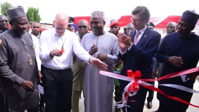
The Lagos State Ministry of the Environment and Water Resources has organised a one-day Stakeholders’ workshop in conjunction with the Nigeria Hydrological services Agency, NIHSA, to evaluate and validate a study commissioned on flood mapping
NIHSA had commissioned the “Flood Vulnerability Studies and Hydrogeological Mapping of Nigeria project in Hydrological Area VI (Western Littoral) Project” to identify causes of and measures for reducing flooding and flood inundation areas across the Country.
In a keynote address during the workshop in Ikeja, NIHSA Director General, Mr. Clement Nze explained that the output of the studies would amongst other things provide the much needed hydro-meterological data for the production of Nigeria’s hydrogeological and flood vulnerability maps, while areas prone to hazards would also been known.
“Substantial stratigraphic data would also become available while areas of data gap to be augmented through exploratory drilling would be identified.
Areas of the country prone to extreme hydrological hazards would become known.
Hydrogeological and Flood vulnerability maps of the country (Hydrological Areas in Sheets) would have been produced. To comply with world best practices standard and requirements for international acceptability of the report and maps, this evaluation / validation workshop is necessary for professionals in the fields of hydrology and hydrogeology is a necessity” he said
He explained that NIHSA in conjunction with the Lagos State Ministry of the Environment and Water Resources would be providing the technical support necessary to ensure the successful completion of the project as required by international standards.
Commending the Lagos State government for its many flood prevention and environmental protection initiatives, the NIHSA Director General Challenged the government to have the political will to fully implement the report of the studies.
In a goodwill message, the Commissioner for the Environment and Water Resources, Mr Tunji Bello who was represented by the Permanent Secretary, Office of Drainage Services, Mr Lekan Shodeinde stressed that the State would not shy away from carrying out it’s responsibility of protecting the environment.
Pledging that awareness campaigns would be carried out to educate residents on the implication of the studies, once the State receives the report,
the Commissioner urged Lagos residents and Nigerians in general to be mindful of the environment.
The Commissioner said “Today’s event is of high significance as it addresses the major challenge of data gap in the water sector. Data remains vital to efficient planning and service delivery particularly in this era where we aim at meeting the goal of providing water for all. As we plan containing flooding in the State, thus the State Government appreciates and embraces your efforts on collection of Baseline data as well as study of flood-prone areas which will help the State to prepare better. We shall continuously collaborate and partner with all Stakeholders.
I believe the importance of flood vulnerability/Hydrogeological maps are valuable for presenting and assessing the local flood situation as
well as provide more information for many applications in flood defence and disaster management”
He lauded NIHSA for its proactive and innovative approach and expressed optimism that the validated report and others like it could become veritable tools to guide decision makers and the public and mold operations such that flooding is abated and access to potable water is guaranteed for all.
The Consultant who carried out the studies, Dr Mathew Offodile said the need for the project arose from the 2012 flooding in the country.
Dr Offodile noted that though vulnerable, but with better management, the flood situation in Lagos State can be contained.


